Routes
Daily stages on map
In the spring of 2000 I bought a CD road atlas program from a bookstore in Tornio at a discount price. It showed a bit of the Norwegian side beyond Kilpisjärvi. One feature that caught my attention was a fell called Rieppegaise, 1410 m high, and not very far from the road. We planned a day trip from the road up to the fell and back, and packed plenty of gear for the outing.
On Friday after work we drove to Kolari, and from there continued toward the Kilpisjärvi area. My parents came along as drivers with a van. We stopped for coffee in Kaaresuvanto. At Kilpisjärvi we camped just past the customs station on the Norwegian side, next to the roadside rest area’s toilet. By evening it was already quite dark and we couldn’t see anything. By chopping pieces from wet wood with a short‑handled axe we managed to get a fire going, and cooked pasta on the Trangia. We slept in a small ridge tent that wasn’t even waterproof, so we had to put a plastic sheet over it. It rained all night.
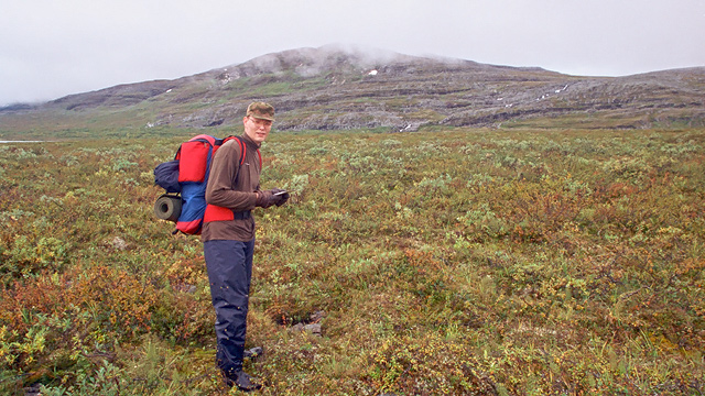
On Saturday morning the tent was very damp, with droplets of water on the ceiling. We got out immediately and dressed. There were no mosquitoes. We then drove along the Skibotn road, looking at the scenery and scouting the terrain. Eventually we parked at the roadside. We left unnecessary items in the car and took a backpack with spare clothes, food, the Trangia, and a sleeping pad.
Rieppegaise
Around 9 a.m. we started walking from the Kilpisjärvi–Skibotn roadside toward Rieppegaise. The clouds were low. At first the terrain was flat, with bogs, shrubs, ponds, and rocky ground, with a few birches. Ahead we could see a steep slope.
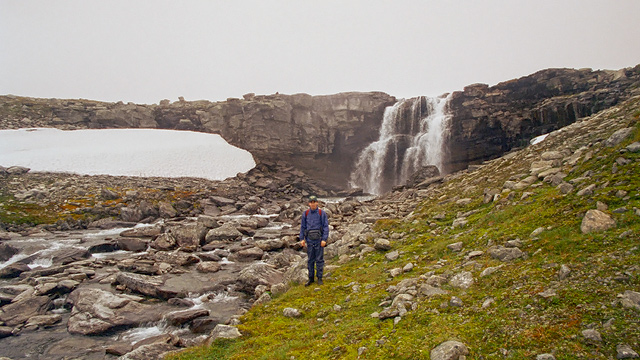
At the foot of the slope we waded across a river, and then began a steep ascent up the hillside, through grass and rock. Higher up we reached a gently rising section made entirely of rock and boulders, with a stream flowing through the middle. Then we came to a steep rock wall and a waterfall. We climbed onto a plateau with a large lake, Bajit Sallojärvi.
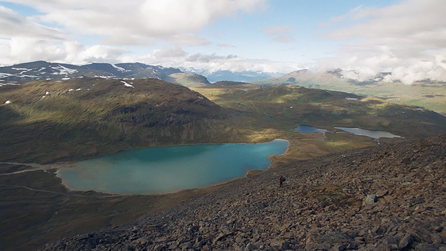
Next we walked along the lakeshore, which was rocky, and then climbed steeply to nearly 1000 meters, using our hands for support on the loose gravel slope. After that the ascent became gentler as we approached the base of Rieppegaise.
Then came a steep climb of about 300–350 vertical meters through loose rock. Just before the summit the slope eased. The sun came out before we reached the top. During the ascent we had views toward the cliffs of Goahterotrassa, and at times the summit of Paras was visible. At the summit, 1410 m, around 2 p.m., there was snow and boulder fields. We could see down to Rihposkohppejavri. We called my parents on the mobile phone and agreed where they should pick us up once we reached the road. We then walked along the fell ridge, keeping to the left side of the peaks. We couldn’t descend earlier because the slope was too steep. The weather cleared and the autumn sun shone. Our drinking water ran out and our thigh muscles began to cramp. After a long stretch of boulder‑hopping we finally found a place where we could just barely descend.
Eventually, sliding down on the loose gravel slope a few meters at a time, braking with our hands and heels, we made our way down to the gravel road by Lake Lavkajärvi. We had traversed the entire fell from end to end. We filled our water bottles from the lake.
We walked downhill along the road to the Kilpisjärvi–Skibotn highway as the sun slowly set behind us. We reached the road at 7:40 p.m. and got into the van. Walking time was 10 hours and 40 minutes, 25 kilometers, with only short drinking breaks and no food. Then we drove to Kolari and stayed the night.
Lessons from the trip: Norway is steep; map printouts from the internet are not very good; there is no water high up in the fells; a proper tent is essential; rubber boots are poor on rocky terrain; and the distance to Kilpisjärvi is long.