Routes
Daily stages on map
For the summer 2024 hike we decided to continue exploring the fell regions of northern Sweden. This time the plan was to hike from Kvikkjokk into the southwestern part of Sarek National Park, into Njoatsosvágge — that narrow valley bordered by high, steep‑sided mountains. Sarek is the most wilderness‑like of Sweden’s national parks: there are no marked trails and no mountain huts. The terrain is rocky and the elevation differences are large in places. There is usually no phone signal. Flying drones is prohibited. These harsh conditions and rules must be taken into account by equipping oneself properly. So we carried, among other things, a weatherproof tent, sturdy hiking boots and a satellite messenger; the drone we left at home. We had previously entered the fells from Kvikkjokk via Padjelantaleden and Kungsleden, so this time we decided to follow Präststigen. This old route from Kvikkjokk to the Alkavare chapel is described in detail in Hans Fowelin’s 2019 book: Präststigen till Alkavare kapell och andra färdvägar i Kvikkjokksfjällen. We would decide the return route to Kvikkjokk during the hike.
Kvikkjokk – Vállevárre
On Monday 24 June 2024 we left Oulu by car at 04:00 and arrived at the familiar parking area at the end of the road in Kvikkjokk at 09:54. In advance we had confirmed by email that the boat transport across Gamájåhkå would be available (https://www.battrafikikvikkjokk.se), and now we phoned the boat driver Helena to agree on the time: 11:00 (Swedish time). This gave us a couple of hours for eating, changing clothes and walking to the boat landing. After eating a mix of pork‑in‑a‑can and pasta in cream sauce and having coffee, we performed the official weighing of the backpacks: 20.46 kg and 24.26 kg. The weight difference was explained by my new summer touring skis, which weigh 3.640 kg. The binding on my previous skis had broken, and now I had built new ones by shortening 1980s downhill skis; the bindings are OAC EA 1.0. My intention was to test the skis on snowy slopes — on our late‑June hikes there has usually still been plenty of snow in the mountains. We arrived at the boat landing slightly early. Soon Helena arrived with her boat.
Music track: Adventures Begin by Pufino
Source: https://freetouse.com/music
Free To Use Music for Videos
During the boat ride we discussed the current conditions in the mountains. Helena told us that summer was early this year, the floodwaters had already receded, and judging by the colour of the river the glaciers had begun to melt. I wondered whether there would be any snow left at all; Helena thought there might still be some higher up. We soon reached the opposite shore and stepped ashore; payment was made by card, 100 SEK/person (9.02 euros). Another boat driver, Björn, arrived — he had ferried us during our 2007 trip. He was quite interested in the summer touring skis, but after hearing their weight he was somewhat sceptical about their suitability for hiking. We chatted for a while and received information about water sources, mosquitoes and boat arrangements should we return this way. Then we headed up the trail towards Prinskullen.
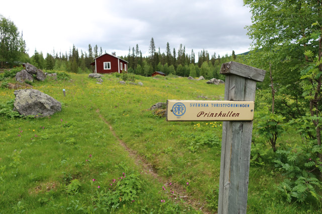
The weather was cloudy but dry and fairly windy. The trail climbed through forest, at first gently and steeper towards the end. It began with pine forest, then spruce, and finally birch before we reached above the treeline. In the natural forest there were many old trees and many fallen ones; only the trail corridor had been cleared. The undergrowth was lush; the peak flowering season had not yet begun.
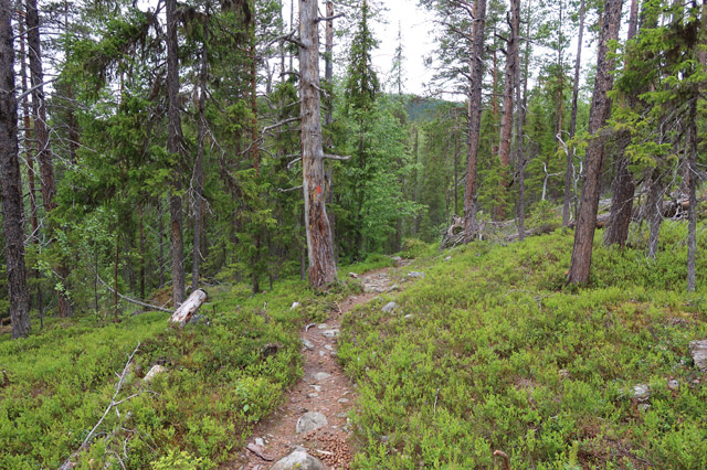
There were many mosquitoes, so we avoided stopping. We drank plenty of water at the last stream Helena had mentioned before Prinskullen — there would be no water on Vállevárre for the next 8 km. From Prinskullen we continued along the ridge of Vállevárre; the wind was brisk and we didn’t get too warm while walking. There were views towards the Pårte mountains. Soon we reached a small pond and camped there at 14:16 (Swedish time), with 10.4 km behind us. The wind continued strong, the weather was warm, +14°C. In the tent vestibule we boiled water with the gas stove and prepared the meal, then ate. The morning’s 450 metres of ascent to Prinskullen had been quite strenuous, so we began resting already at 19:00. Cloudiness increased and it rained a little during the night.
Vállevárre – Biernnagájsse – Vállevágge
On Tuesday 25 June 2024 we woke at 06:00; it was still drizzling slightly, but the rain soon stopped. After breakfast and coffee we packed our things and at 08:32 began heading towards Vállevágge. The clouds were low and it was windy, so mosquitoes were not a problem. We first climbed gently above 1000 metres, then the terrain levelled out. The wind was stronger up here. After 4 km we took a break behind a rock sheltered from the wind and ate chocolate bars. We continued into a brisk headwind; the weather cleared a little and the sun appeared briefly. As the side slope of Vállevágge steepened, we stopped at a stream to drink. At that moment I noticed that the GPS/satellite messenger hanging from my chest strap had fallen off! We searched for it for a long time, walking even 2.5 km back to the break rock, but we did not find it. We had agreed to send an OK message home every day via satellite; now there was a risk that the family would alert authorities when no messages arrived. After some thought we decided to stop for camp as soon as we found a tent site and then climb up the mountain — perhaps the phone would get signal there and we could call home. We also decided to shorten the route somewhat: instead of Njoatsosvágge we would visit Låptåvákkjávrre, then return this way and search for the GPS device again, using 1–2 days if needed. For navigation we would manage without the GPS — I had a map and compass, and my hiking partner had GPS and map software on the phone and a compass in the sports watch. We continued another three kilometres until we found a suitable tent site at 13:14; distance walked was 9.1 km, plus 5 km searching for the GPS. We pitched the tent and ate chocolate bars. At 17:12 we began climbing higher towards Tjilákboarkka. Higher up there was still some snow, so I had my skis with me. The longest continuous snowfield was in the stream gully, extending from just under 1400 metres down to just under 1200 metres; I left the skis above this snowfield. We continued climbing; the rocky slope was fairly steep. At about 1500 metres the phone worked and we reached the family. We explained the situation — daily messages should not be expected — but reassured them that we would probably survive this trip even without messaging. We ate chocolate bars and considered our options; it was windy and the rocky slope was steep, but since we were already here, we might as well climb the summit of this mountain, Biernnagájssse. We continued climbing; the slope was gentler higher up, and we soon reached the 1834 m summit. There were some views and plenty of wind. We didn’t bother continuing to the neighbouring 1828 m Tjiláktjåhkkå summit. We then descended, taking another break to eat chocolate bars. Near the snowfield I switched to skis for a test descent.
Source: https://freetouse.com/music
Free To Use Music for Videos
The snow was not optimal — this was summer snow, hardened by sun and wind, and the skis did not sink into it much. On earlier trips the snow had been early‑summer snow, with a soft, coarse‑grained surface layer into which the skis sink 5–10 cm during turns, making skiing easy. Now the hardness of the snow and the steepness of the slope demanded more from my thigh muscles than they had to offer after the recent ascent, and I had to stop a couple of times to rest my legs. The skis themselves worked excellently — they were stable and the hiking boot stayed firmly in the binding. We returned to the tent at 21:37 after walking 6.76 km. We enjoyed a late dinner before resting. After the first two days, this mountain hiking felt quite strenuous, and since the amount of snow was small and its quality summery, I decided to leave the skis at this camp and pick them up on the way back. Perhaps with a lighter pack my legs would lift better and my stride would lengthen.
Vállevágge – Buojdes
On Wednesday 26 June 2024 the night was windy and cold. We woke at 07:00; outside it was +6°C. After breakfast I went to cover the skis with stones. We then broke camp and at 09:30 began walking up Vállevágge. The weather was cloudy but dry and windy. The upper part of Vállevágge was rocky. After that followed a long rocky descent into Ruonasvágge. In places we saw stone markers, possibly old Präststigen markers. There was still a snow bridge over the stream descending from Málmmatjåhkkå, which we used. There were views towards Tsahtsa and Pårte. In Ruonasvágge we crossed the stream on stones. After the crossing we took a break sheltered from the wind and ate chocolate. After resting enough we continued up to the next mountain ridge. After crossing the ridge we descended into Slihtavágge and from there climbed again over a ridge to a small lake. Then followed a descent towards Lake Buojdes. Shortly before the lake we saw a good tent site on a small rise to the left above the lake. We camped there at 14:18, having walked 12.44 km.
Source: https://freetouse.com/music
Free To Use Music for Videos
This section of the route was fairly typical fell terrain without particular sights, though searching for old route markers provided some interest. In the rocky terrain even this relatively short day felt sufficient. The wind continued and the lake had waves, but now the sun was shining and the camp was pleasant; the tent was warm. The lake water was cold enough that swimming was out of the question, but washing one’s face was possible. We ate dinner in the tent.
Buojdes – Låptåtjåhkkå – Låptåvákkjávrre
On Thursday 27 June 2024 the night was fairly cool. We woke at 06:00. The sun now shone brightly, with only a few clouds; the lake was mirror‑calm and there was no wind. This kind of weather is rare on a hike — then being in the mountains is easy, you don’t get cold and the views are clear. Of course, one must remember UV protection and to drink enough water. After breakfast and breaking camp we began walking at 08:05, easily crossing the stream flowing from Lake Buojdes on stones and following the lakeshore northwest, climbing diagonally. Soon we were at Lake Bajep Buojdes, with views opening towards Padjelanta — Vuoksákvahta was visible, then Stájggá, then Gierggevárre. It was warm walking in the sunshine; no jacket was needed. We took a break after 6.2 km and ate chocolate. Then we soon began climbing diagonally to the right. Since the weather remained exceptionally fine, we had the idea to visit the summit of Låptåtjåhkkå. We climbed to about 1240 metres, left the backpacks there, and then headed up the slope towards the 1573 m summit. The ascent was easy — hardly any rocks and not very steep. From the summit there were fine views towards Pårte and Padjelanta, and Sulitelma was also visible. South of the summit there was a small glacier.
Source: https://freetouse.com/music
Free To Use Music for Videos
We enjoyed the favourable weather — it was warm and windless, and without the backpacks we felt light. This moment was the highlight of the entire trip. We took a few photos. Then we returned to the backpacks. After sitting for a moment we shouldered the packs and then descended rather steeply, partly along snow patches, into the gully leading down to Låptåvákkjávrre. The gully offered an easy route; a stream flowed there, providing water. We continued down to the northern end of the lake and camped at 15:49, having covered 15.72 km. The sun was still shining and the tent was too hot. This time we ate outdoors. We planned a day trip for the next day, weather permitting.
Låptåvákkjávrre – Tsahtsa – Låptåvákkjávrre
On Friday 28 June 2024 we woke at 06:00. The weather was now partly cloudy; the clouds were at the height of the highest summits, and a fairly brisk wind blew from the southeast. After breakfast and coffee we packed the items needed for the day trip and at 08:05 set off towards Mount Tsahtsa. It is a fairly high mountain, 1857 m, and if the weather allowed, we could expect wide views and perhaps see down into Njoatsosvágge. We first walked along the grassy slope by the lakeshore, climbing gently. Ahead was a difficult boulder field; after that we reached a gentler plateau near a stream. We filled our bottles there. We continued climbing gently towards the visible stream channel. There was still snow in the channel, and we were able to ascend easily on snow from 1200 to 1400 metres. Then came a gentler rocky slope to 1500 metres, after which the rocky slope steepened noticeably. The steepness continued all the way to 1800 metres; the left side of the slope seemed slightly gentler, so we climbed that way. We occasionally used our hands for balance, but no actual scrambling was required. The rocks were not very loose, even though the steepness might have suggested otherwise. Having learned from last year’s experience, we had left the trekking poles at the tent — here they would only have been in the way. At 1800 metres we reached the summit ridge; the slope eased and we arrived at the gently rising plateau leading to the summit. The summit was in cloud and visibility was zero. The summit was marked by two cairns. We sat for a moment, then the clouds thinned and visibility opened first down into Njoatsosvágge, then more widely.
Source: https://freetouse.com/music
Free To Use Music for Videos
We ate chocolate bars in the shelter of the rocks. We examined the western ridge of Tsahtsa but decided to descend the same way we had come — that way we would not encounter any surprises. From the summit ridge we still had views towards Pårte. The 300 metres of descent in the steep rocky slope was very slow and laborious; we had to use our hands for support at times. The final stretch back to the tent was easy; we arrived around 14:00, having walked 12 km. We ate chocolate bars and broke camp. We had decided to begin the return journey. The southwestern shore of Låptåvákkjávrre is generally not recommended as a route because the slope of Låptåtjåhkkå descends steeply into the lake, but we decided to follow it anyway to avoid wading the stream at the southeast end of the lake. We are not particularly fond of wading — the water is cold and wet, and the rocks are slippery — so we avoid it when possible. In addition, crossing the Skievvun ridge would allow us to shortcut to Lake Buojdes and avoid the brush of Tjuoldavágge. At 15:30 we set off; walking along the lakeshore was fairly easy, with only a couple of short boulder sections and a snow patch sloping into the lake to cross, after which the shore became normal walking terrain. We covered 2.61 km and camped at 16:30. Cloudiness increased, a warm southeast wind continued, hinting at rain. After dinner we went to rest.
Låptåvákkjávrre – Buojdes
On Saturday 29 June 2024 we woke at 06:00. It was cloudy, the clouds at 1200 metres, and it was drizzling. After breakfast and coffee we began walking at 08:00. We climbed the slope diagonally, then more steeply along the stream. The rain increased. Higher up the terrain became rocky. Visibility soon disappeared as we entered the clouds. A GPS device would have been useful now. We checked altitude on the wristwatch — we reached 1273 metres. Then we decided to head west; I remembered that there should be a descending slope in that direction. I also remembered the long snow-filled stream channel we had seen on the way in — we could descend easily along it. We walked across the plateau for a while on compass bearing, then the slope began to descend. Following the water drainage lines we found the small lake at 1213 metres where the stream channel began. The wind was now strong and the rain heavy; our clothes and boots were getting soaked. We descended easily on snow to 900 metres, then continued down to the right until we saw the waves of Lake Buojdes through the fog. We crossed the stream flowing from the lake. The rain was now heavy and soaking everything; we were very wet. When we saw our previous campsite on the lakeshore rise, we decided to head there to camp and wait out the rain. We camped at 11:00, having walked 7.1 km. Our boots were completely soaked, and I thought that I must change footwear type in the future — these Gore‑Tex hiking boots always get wet in heavy rain and never dry during the trip. We changed into dry clothes, inflated the sleeping pads and waited. The rain stopped at 15:00 and soon the sun came out. We marvelled at our good luck — sometimes fog and rain have continued for days, as I recall happening in 2008, 2016 and 2023. We spread our gear outside to dry in the sun. Our plan was to continue hiking after drying.
However, the sunshine ended at 17:00 and it began to rain again. We quickly gathered our gear into the tent. We decided not to continue further that day. A thunder shower came and went quickly, and the rain continued. After dinner we went to rest.
Buojdes – Vállevárre
On Sunday 30 June 2024 it rained during the night, but not in the morning. We woke at 06:00. The weather was now cool, with a northwesterly wind. After breakfast and coffee we broke camp and at 08:00 began walking along Präststigen towards Kvikkjokk. Our boots were still wet, so we wore plastic bags over our socks to keep our feet warm. The route was now familiar. We walked first into Slihtavágge, then into Ruonasvágge. The weather remained partly cloudy. During the ascent from Ruonasvágge the weather brightened slightly. We took a break after passing a small lake, then continued up into Vállevágge. In Vállevágge we walked along the snow strip by the stream for 1.6 km until we reached our previous campsite. I picked up the summer touring skis and we continued. Our intention was now to search for the GPS device. If we found a tent site near the search area, we would camp and search for 1–2 days if needed. We reached the point where I had noticed the device was missing. We left the backpacks there; I began scanning the terrain and recalling our route. After about 100 metres I reached a small rise, looked around for the colour orange — and there it was, the GPS lying on the ground a few metres away! It was intact and the battery still had 61% charge. I shouted and waved to my hiking partner that the search was over.
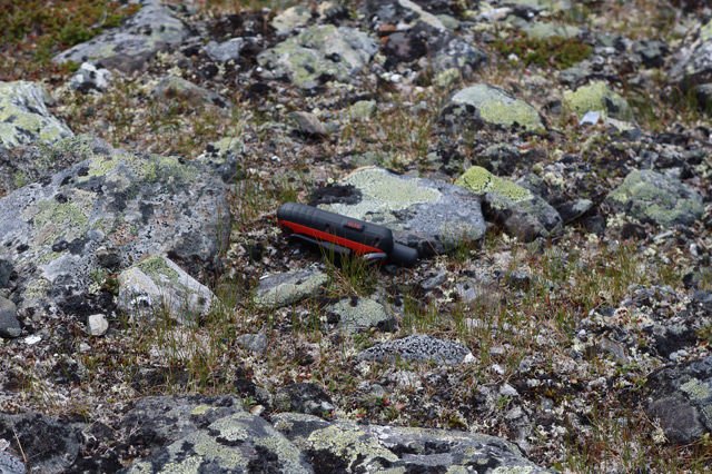
I returned to the backpack, stored the GPS safely, and we continued. Soon the weather alternated rapidly between rain and sunshine; we changed into and out of shell clothing at least twice. Descending Vállevárre we saw two hikers ahead — the only people we saw in the mountains. We passed them at a distance and reached the familiar campsite by the pond. We camped at 16:30, having walked 22.03 km that day. The sun shone into the camp and the weather was calm. We ate dinner. At this campsite the phone and internet worked; we listened to the 20:30 news (Finnish time).
Vállevárre – Kvikkjokk
On Monday 1 July 2024 we woke already at 04:00 so that we would have plenty of time to drive home. After breakfast and coffee we packed our things and began walking towards Prinskullen. The weather was cloudy, no rain, little wind. We reached Prinskullen fairly quickly and searched for a while for the descending trail. Once we found the trail we walked to the point where there is a sign placed by the boat drivers. From this point it is three kilometres to the boat landing, taking about an hour, and Helena had instructed us to call her from the sign so she could be ready with the boat. We called and arranged the transport.
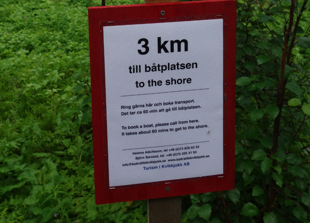
There were so many mosquitoes in the forest that we had to walk quickly, and we reached the boat landing in half an hour. The boat arrived soon and we boarded. Helena asked about the skis and I explained how the test descent had gone. Then Björn arrived in another boat and I recounted the skiing experience again to him and to a hiker he was transporting. At the Kvikkjokk boat landing we stepped ashore and said goodbye to Helena. We then walked up to the parking area. There we encountered an unexpected problem — the car battery was dead and the car would not start. We changed from hiking clothes into travel clothes and considered our options. I recalled that in the old days cars were push‑started; the road from the parking area goes downhill, so surely the car would start. We pushed the car downhill; my hiking partner jumped in as driver. The car rolled down and disappeared behind a bend. After a moment the driver walked back up — clearly the car had not started. We continued thinking and decided to walk to Kvikkjokk Fjällstation to ask for help. The reception/shop/café was open. We talked with the staff and their supervisor. The supervisor said that they intended to discuss the matter in an upcoming staff meeting and consider whether offering jump‑start assistance would be possible. We sat at the mountain station for a while, sheltered from rain and mosquitoes. Then we returned to the car to drop off our travel bags. At the car we met a friendly and helpful woman, presumably a local resident, who, upon hearing of our problem, immediately arranged help. She phoned Helena, who soon arrived with a Volvo and jumper cables. However, we could not get enough power from the Volvo — the car would not start. We returned to the mountain station, ordered coffee and pastries, and continued considering the situation. The staff did not approach us at all, so apparently no help was forthcoming from that direction. We decided to rely on the traffic insurance company — even though it was LähiTapiola, perhaps they could arrange help even here in the wilderness. And indeed, after 3.5 hours of waiting (sitting at the mountain station, walking around Kvikkjokk village and the churchyard, explaining the ski test once more), a gentleman arrived from Jokkmokk (Autotech i Gällivare AB) with a jump‑starter. The car started, and we drove home.
Notes: The newest version of the summer touring ski is quite heavy, so skis should only be taken on a hike if there is plenty of snow, such as in winter or spring. The GPS device must be attached more securely in the future, e.g. hanging from the neck and also placed in a jacket pocket. The Hanwag Alaska GTX hiking boot does not seem to stay waterproof; now I must finally get Lundhags shell boots for testing. The Therm‑a‑Rest NeoAir Uberlite L sleeping pad worked flawlessly for my hiking partner, and the battery‑powered pump helped with inflation.
The boat transports in Kvikkjokk work extremely well — the ride is inexpensive, and the boat drivers provide important information about routes and conditions. Their help with the car problem was also very kind. A diesel car apparently requires pre‑heating before starting; without battery power the glow plugs cannot heat and the engine will not start, not even downhill. We will likely have to return to Sarek again — this visit ended up being only a one‑day excursion.