Routes
Daily Stages on the Map
Inspired by last year’s May mountain hike, I headed back to the Abisko Alps to practice (spring) winter hiking. This time, I headed for the fells right at the beginning of May, hoping there would be more snow than the previous year. I still don’t have a sled, so I had to pack everything into my backpack. To keep the backpack’s weight reasonable, I brought only one pair of skis.
Thursday, April 30, 2026: Travel by car to Kolari, where spend the night.
Abisko – Čuonjávággi
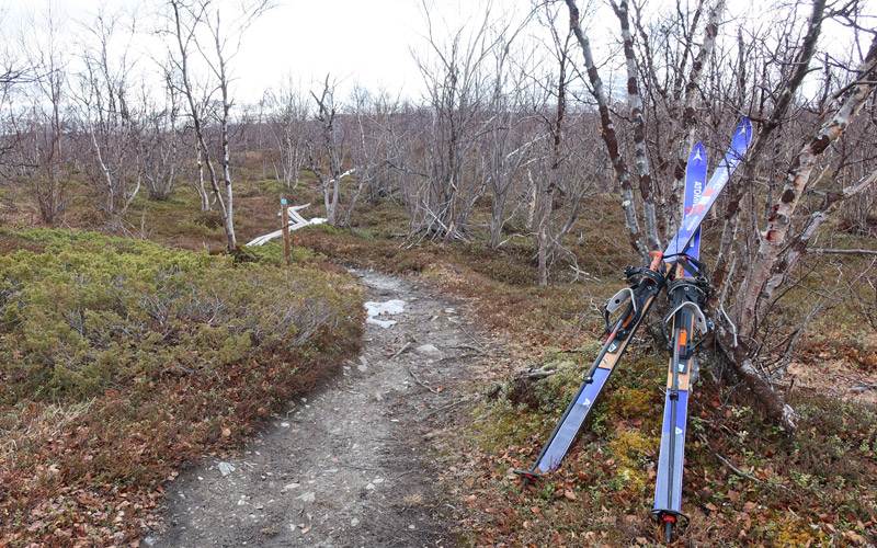
Friday, May 1, 2026 I woke up at 6 a.m. and, after breakfast, set off by car toward Abisko. The trip went smoothly, and by 10 a.m. I was in the parking lot at the Abisko Turist train station. I packed a few more items into my backpack and the pockets of my jacket. Just in case, I slipped a half-liter bottle of Coke into my pocket. The weather was warm, 8 degrees Celsius, cloudy, but no rain and not much wind. There was no snow in sight in the immediate area, so I had to carry my skis in my hands.
Choosing the right skis had been on my mind all winter; I had been debating between actual mountain skis, OAC XCD GT gliding snowshoes , and a pair of homemade mountain skis of sorts. Mountain skis would have required bringing BC boots, and in addition to the boots, I would have needed another pair of shoes, since the boots are hard to walk in. The gliding snowshoes, on the other hand, were annoyingly prone to slipping sideways and felt unstable when I tried them out on packed snow in the winter. So, I settled on DIY mountain skis—specifically, 175 cm-long slalom skis from the ’90s, to which I had attached OAC 1.0 snowshoe bindings. For footwear, I wore Salomon Toundra winter boots; I had already skied in them during the winter and found them to be good and warm.
Day Trip to Váimovággi
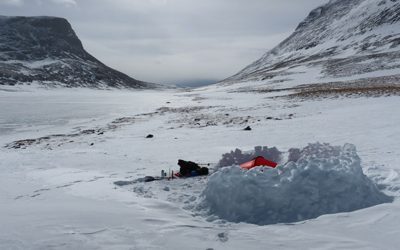
Saturday, May 2, 2026 I spent the night trying to sleep; my wool jacket was quite warm, so I switched to a lightweight down jacket—the hood on the down jacket also provided better protection for my neck. I woke up at 6:23 a.m. I ate the rest of the Reiter from the bag for breakfast, drank coffee, and ate some cookies. The weather was cloudy and windy; the wind brought snow flurries, though the sun peeked out occasionally. I decided to check out the surroundings a bit and set off skiing toward Váimovággi, carrying my day trip gear in my backpack. The wind was strong, but fortunately it was at my back. I first climbed up the snow-covered ridge, then walked on rocky terrain with my skis on for a while until I reached the southern edge of Váimovággi. There was still snow there, and I was able to travel mostly on snow, though my skis had climbing skins, so I could walk uphill or on flat ground or slide downhill; there wasn’t enough glide for actual skiing. I made it to the base of the gorge between the peaks of Čuonjáčohkka; a strong wind was whipping snow down the slopes of the fells. With a wind this strong, summiting the fell was out of the question. Besides, it felt like too strenuous a feat given my condition that day—first a 500-meter climb to the 1,495-meter peak, and then I’d have to continue on to the 1,562-meter peak. The snow on the slopes was icy; my skis left hardly any tracks in it. I continued on skis and reached the saddle between Čuonjáčohkka and Suorooaivi; here the wind was even stronger. I started descending diagonally to the right, but then realized there was likely a snowdrift ahead, so I turned left and went down from there. I managed to get around the snowdrift; lower down, the wind was lighter, and I took a sip of water from my bottle. The snow didn’t hold well in this flatter area; my skis sank into the snow at times, and at other times there was no snow, and the tips of my skis jabbed into the uneven ground. I then climbed back up the slope where the snow held. I reached the southern side of the fell, up on the ridge; the wind was really strong there, and the snow ran out. I took off my skis and carried them in my hands. The wind caught the skis and almost knocked me off balance. I made it to the edge of Čuonjávággi; at one point I had to squat down on my knees there to wait for the gust of wind to subside. Behind a slightly larger rock, sheltered from the wind, I then took a break, ate a chocolate bar, and drank some water. After a break, I descended into the lower part of the valley, where the wind was a little lighter, though snow was blowing in with it. There was snow on the ground at the bottom of the valley, so I put on my skis. Visibility was poor in the cloudy valley; I walked on skis against the wind and snow flurries, with snow piling up on my glasses and the front of my jacket. Finally, near Čuonjájávri, the cloud cover and flurries lessened, and the wind died down a bit. I continued along the lake shore back to the tent. Fortunately, the tent was still in place, sheltered by a wall of snow; I reached it at 2:50 p.m. I ate a beer sausage, took off my wet socks—Toundra boots are so warm that my feet sweat a lot in them. Then a blizzard began, blowing snow into the tent as well; the snow soon covered my gear in the vestibule, and I had to keep the inner tent door closed, otherwise the inner tent would have been full of snow too. I waited for the snowing to end and tried to shake the snow off the top of the inner tent. Finally, the blizzard passed; I cleared the snow from the vestibule and lit the stove to dry out the tent, and at the same time prepared a Reiter Pasta Carbonara with Ham meal, which, as has already been noted, is also a really good dish. Getting around on skis had felt pretty awkward. You couldn't exactly call it skiing; it was more like walking with skis on. The skis also had poor downhill performance; fortunately, the climbing skins provided some braking on the descent, but I had to use plowing turns, and even then I fell once. I wouldn’t have the stamina to make long treks on skis with a backpack on my back. The climbing skins were also now wet and frozen. So I decided to focus on camping for now. In the evening, I enjoyed some coffee-cocoa and ate some cookies. Then I started waiting for sleep; it was -4 degrees outside. The GPS showed the day’s distance as 17.08 km, time 6:00:28, speed 3.3 km/h, ascent 858 m, descent 890 m.
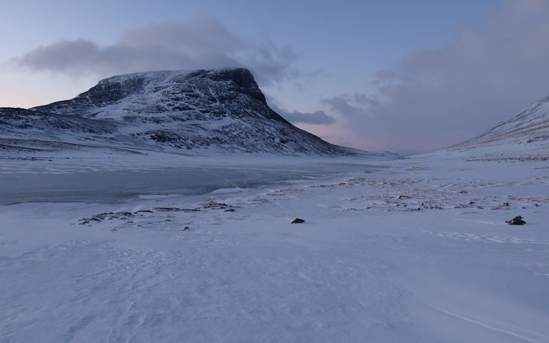
A trip to the ravine north of Nissončorru
Sunday, May 3, 2026 It was chilly at night: -8 degrees Celsius in the outer tent and -4 degrees in the inner tent. I felt a bit cold at times; my quilt’s temperature limit is -6 degrees. At 3:15 a.m., I stepped outside; my shoes were frozen, and drifting snow had covered the tent’s vents, so I cleared the snow away with a shovel. I brought the water containers into the inner tent so they wouldn’t freeze completely.
Čuonjávággi – Abisko
Monday, May 4, 2026 There was no wind during the night, so condensation built up inside the tent, and the dampness made me feel a little chilly; the temperature inside the tent was -4 degrees. I missed my down sleeping bag a little, but I left it packed in its compression bag and made do with a quilt. I woke up at 7:40 a.m.; the sun was already warming the tent, there was only a light breeze, and hardly any snowfall. I ate the rest of the Reiter bag, drank coffee, and had some cookies. Then I packed my gear under the shelter of the tent; finally, I went outside, took down the tent, and packed everything into my backpack. Thanks to the favorable weather, breaking camp went smoothly. In general, I believe it’s better to set out when the weather is good. The usability/uselessness of the skis had now been verified in so many different ways
that I packed them on the sides of my backpack as well.
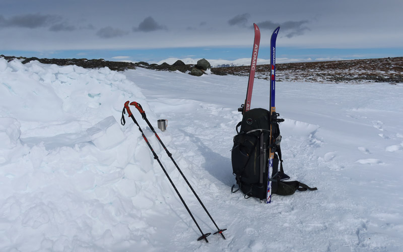
Observations: First of all, there just wasn’t enough snow. Second, the skis were poor; I had already noted last year that skis play an essential role in winter hiking and that it’s best to have mountain skis when hiking in the fells. However, in such poor snow conditions, those spare skis—which hadn’t been used in three decades—were perfectly suitable; they handled well even on rocky terrain and in grassy areas. It’s so that early May is unsuitable for fell hiking, when skiing is no longer feasible and hiking isn’t yet possible, Q.E.D. The Abisko Alps are a really nice mountain range; I’ve just often visited there outside of summer, so the weather has usually been bad; one could even take a summer trip to the area, starting from the Kaisepakte parking lot. A quilt is perfectly sufficient for summer trips, at least with a Therm-a-Rest NeoAir X-Lite NXT mattress. The Akto is a cramped tent.