Routes
Daily Stages on the Map
For the summer hike of 2025 we had planned to visit the Kebnekaise fell area, with particular interest in Påssustjåkka/Bossosčohkka, a 1949 m high fell. Approaching the summit via the western ridge should be easy, and the views from the top would surely be memorable. As in our 2022 hike, we would again begin the walking section from Čunovuobmi in Norway. The drive there is a bit longer, but the area is much quieter compared to Nikkaluokta and Abisko. Since the hike would take place in August and July had been very warm, it was now appropriate to leave the summer touring skis out of the gear. We prepared for a maximum of 10 days with an “all‑inclusive” style — everything needed would be carried in our backpacks. In the Kebnekaise area it is of course also possible to buy food from the fell hut shops and stay in the huts. Otherwise too, the area is very suitable for hiking: marked trails and bridges over waterways make travel easier.
Thursday 14 August 2025. Driving to Kolari, refuelling and overnight stay. On the way we discussed the weather forecast for our destination area, and it was not very favourable. The Finnish forecast also predicted rain and strong winds for the weekend.
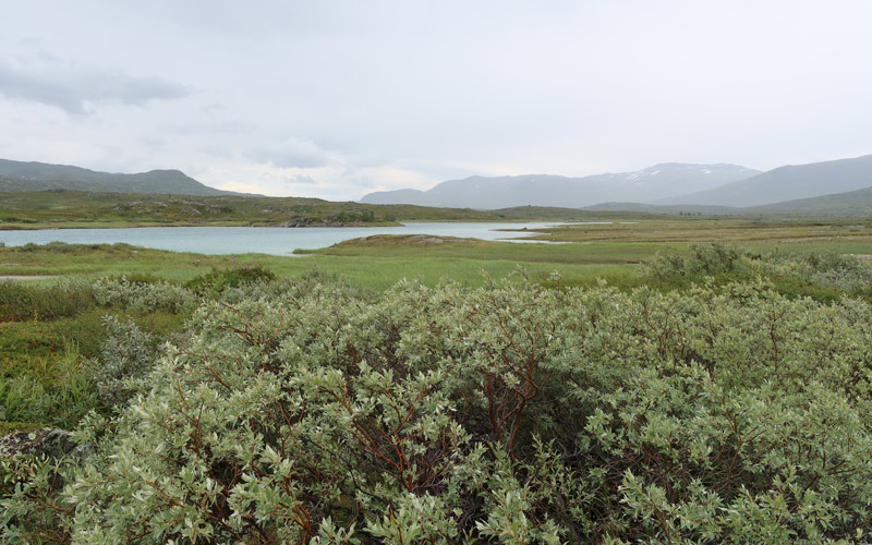
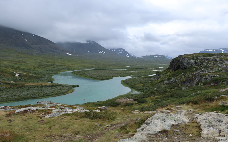
Čunovuobmi – Pond 1127 m before Goržžijohka
Friday 15 August 2025. We woke up around 04:00 and ate breakfast. Because of the weather forecast we already prepared to wear shell clothing. At 04:34 we started driving to Sweden. In Pajala we encountered a road closure and had to take a detour. Then there was roadwork for some distance. We drove past Kiruna into Norway, turned onto the Skjomen fjord road and then onto the Norddalen road. At the end of the road we parked the car by the lake at 639 m, where the trail begins. Rain threatened, the sun was faintly visible through the clouds, and the weather was fairly warm. With the Trangia we prepared the traditional starting meal: pasta in cream sauce with meatballs. After that we enjoyed milk coffee and white‑chocolate cranberry biscuits. Then it was time to put on the shell clothing, hoist the backpacks (weights 18.70 kg and 21.78 kg) and start the GPS device, sports watch and phone map app. We began walking around 11:00 (Norwegian time), and rain started soon after. We walked to the bridge crossing the Iselva; the river had plenty of water, whereas the lake was not very full. After the bridge the route turned uphill. We decided to shortcut a bit and follow our own path toward the Čaihnajohka bridge.
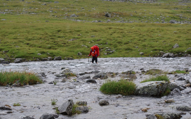
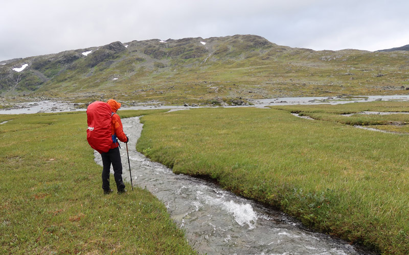
At first the walking was easy, crossing some smaller branches of the Iselva. Then we reached a more forceful stream that could not be crossed without wading. We headed upstream to look for a crossing point, as we did not want to wade. Soon we found ourselves in dense, tall and wet willow thickets, and the rain intensified. We followed the meandering stream through this thicket, and the going was difficult enough to establish a hiking rule of thumb: if you see woody vegetation, stay on the trail. Eventually we found a place to cross the stream. Soon the Čaihnajohka bridge came into view. At the bridge were two hikers who continued toward Čaihnavággi. We crossed the bridge and continued toward Gállanjohka. We followed the river upstream. The constant rain, shell clothing and physical effort had already caused all clothing, shoes and socks to become wet. We began examining possible crossing points of Gállanjohka to continue into Sweden. We tried a couple of places, but it became clear that wading was necessary; otherwise water would enter the boots (some already had a little). We changed from hiking boots to Feelmax barefoot shoes (an old model, in use since 2007 according to our notes) and waded across the stream.
After putting the hiking boots back on, we began climbing eastward toward Sweden. During the steepest ascent the rain paused, then the slope eased, we reached Sweden, and the rain resumed. We reached the saddle between Rádječohkat and Gállanvárri at about 1220 m, took a break and ate chocolate bars. We then descended south of two small lakes along steep snow patches. We were already thinking about finding a tent site, and near the third lake at 1128 m we found one. The weather was foggy with little visibility. The wind made pitching the tent a bit difficult, and as usual the tent had shrunk slightly when dry, requiring force to seat the poles in their sleeves. We got the shelter up and moved inside. The rain continued heavily, the wind eased slightly. We changed into dry clothes. We had walked 15.83 km, time spent 7 h 46 min, ascent 908 m and descent 384 m.
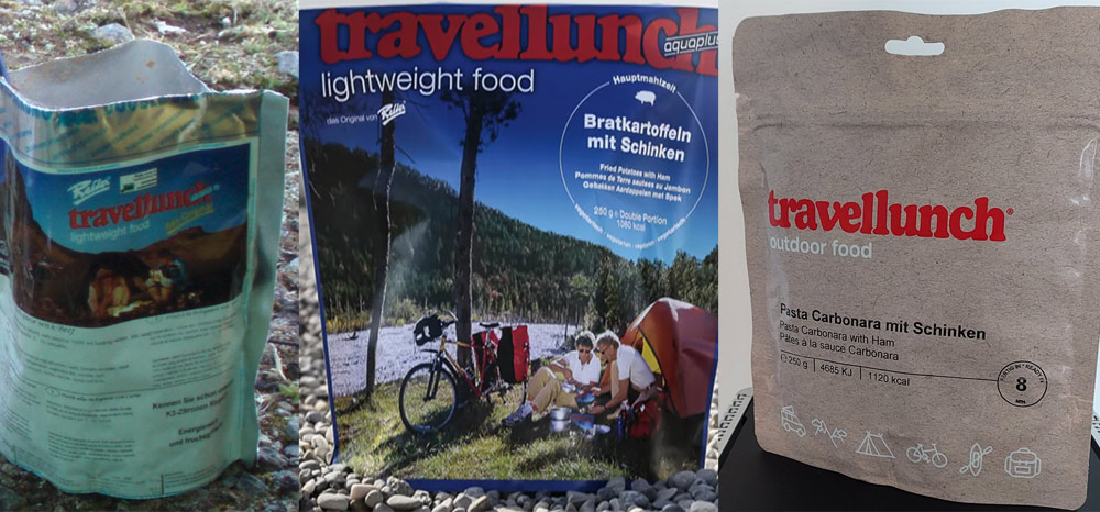
It was now time for the evening meal. This year our food supplies had undergone a change, as the colour of the Reiter meal pouches had changed. Reiter Beef Stroganoff with Rice was now on the menu. Then it was time for rest/sleep.
Pond 1127 m before Goržžijohka – Alesjaurestugorna
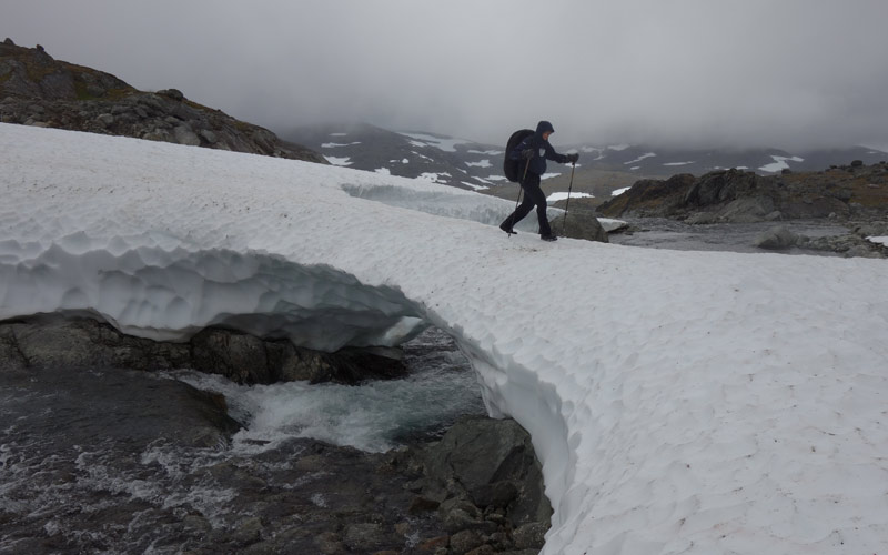
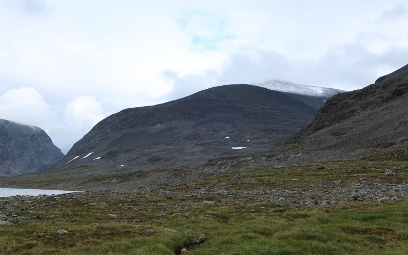
Saturday 16 August 2025. It rained all night, and there was wind as well. Wake‑up was at 09:00 (Swedish time). For breakfast we had Reiter Pasta with Beef and Pepper Sauce. We did not want to head out into the rain, so we stayed put and rested while drying our wet clothes. Around noon we had coffee and biscuits. Eventually the rain stopped and we decided to continue. We packed up camp and at 14:20 headed toward Goržžijohka. The stream was less than half a kilometre away. The plan was to cross it and continue east toward Alisvággi. However, the stream had so much water that wading would have been necessary. We walked upstream looking for crossing points, but there were none. Wading did not appeal now — the water would be cold and the current fairly strong. We decided to go around Bajip Goržžijávri; this would also allow us to explore this fell area, where we might not return again. On the opposite shore we saw the stream flowing from the 1228 m lake, also fairly strong; we thought that if necessary we would go around that lake as well. The terrain in this region is very rocky and bare, likely because younger Scandic mountain nappe rocks have eroded away from the ancient bedrock (urbergsfönster, “bedrock window”). Light rain came and went, and the wet rocks were slippery, so our progress was slow. We saw the glacier on the eastern slope of Gállanvárri. On the southern shore of the lake, snow patches made travel easier, though they were quite steep. We climbed slightly upstream along the stream from the 1228 m lake and found a snow bridge, allowing an easy crossing.
We then took a chocolate bar break. Next we continued south of Snárapoaivi toward the saddle between Čoalmmioaivi and Gárdečohkka. Here runs the marked summer and winter route from the Unna Allakas fell hut. The terrain was easier here. We walked downhill toward Alisvággi. At a large boulder on the edge of the valley we took a break and ate chocolate bars. We decided, as dusk approached, to camp at a familiar spot about a kilometre southwest of the Alesjaure huts. We found the site and around 22:00 pitched the tent. During the day the rain had been light enough and the walking slow enough that our clothes were dry except for socks and shoes. The day’s distance was 17.29 km, time 7 h 41 min, ascent 542 m, descent 889 m. By the light of the power bank’s LED lamp we prepared Reiter Chicken Korma Curry for supper. Then we attempted sleep.
Alesjaurestugorna – Western end of Unna Visttasvággi
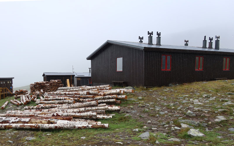
Sunday 17 August 2025. The night brought moderate, cool southerly wind, but no rain. Wake‑up was at 09:00. Outside, a uniform cloud layer hung at about 1200 m, and the wind continued. From the backpack we found breakfast again: Reiter Pasta with Beef and Pepper Sauce. Then instant coffee and biscuits. Again we rested a bit, as the weather was what it was. Eventually we set off, first to the yard of Alesjaurestugan to sense the international atmosphere, then across the Aliseatnu via the bridge.
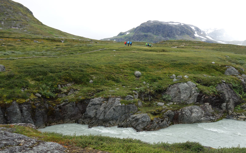
Now we were on Kungsleden, one of the world’s most famous and perhaps best hiking trails, running through Lapland’s fells and alternating dramatically between alpine scenery and fell birch forests. Fortunately we were not in birch forest now, but neither were there alpine views. There were boardwalks, rocky sections and some muddy spots. A few other hikers were on the trail, but not many. We followed the trail until we turned left toward Unna Visttasvággi, where there would be a suitable base camp from which to attempt Påssustjåkka. First we walked to a stream descending from above; it had a small waterfall. We took a break in its wind shelter and ate chocolate bars. Then we climbed fairly steeply upward. When the slope eased, we began scanning for possible tent sites. We found a stone‑free grassy and mossy area suitable for a tent at about 1058 m, with a stream nearby. The cool, even cold wind continued, and it was cloudy. The upper part of Påssustjåkka was visible briefly — it had received fresh snow. We set up camp and rested again, as there was nothing else to do. Wet socks had caused some chafing on our feet. The day’s distance was 7.60 km, time 3 h 8 min, ascent 445 m, descent 210 m. At this tent site there was phone reception, and we checked the detailed weather forecast from yr.no. For the next day, Påssustjåkka’s summit would have a few degrees below zero, snowfall and wind of 18 m/s, gusts up to 25 m/s, wind chill –15°C. The temperature outside the tent was now +4°C. We began to consider that such weather would not be suitable for a summit attempt — it would not be easy, and there would be no views.
After discussing the matter for a while, we decided that the summit attempt would be cancelled, though we could still monitor the weather. Reiter Beef, Noodles and Mushrooms was the evening meal — one of the best Reiter dishes. Then we tried to sleep again.
Western end of Unna Visttasvággi – Luoktekjávrrit 913 m
Monday 18.8.2025 during the night it rained and was very windy. Wake‑up was at 07:00. One tent peg had come loose during the night. The rain continued, the clouds were low, and the wind remained strong. So it was not suitable weather for a summit attempt. For breakfast we ate a Reiter Chicken Korma Curry meal, followed by morning coffee and biscuits. The wind shook the tent and pegs came loose again. The ground here was soft enough that the pegs would not hold. We decided it was best to head lower; there would be no going to Påssustjåkka now. We packed our gear and around 11:00 began descending diagonally toward the Bossosjohka bridge. Lower down the wind was slightly weaker, the rain continued moderately. We crossed the bridge and were back on Kungsleden. Around us were at least 14 other hikers. On the clear trail with plenty of boardwalks, walking was easy and fast, and soon the other hikers were behind us.
The headwind from the south strengthened, and the rain increased. Shell clothing and shell mittens were necessary; the atmosphere was like being in a car wash. With a brisk hiking pace we were soon near Tjäktastuga. We had considered the possibility of a summit trip to Tjäktjatjåkka, but now that the weather was like this and the forecast did not promise improvement, we abandoned that idea as well. We crossed the bridge to Tjäktjastuga and took a break on the sheltered side of one of the huts, eating chocolate bars.
Now that all summit ambitions had been completely abandoned, the only thing left was to return to the car. It was possible — if things went as they usually do — that the weather would soon improve now that we had given up our goals. A possible route back to the car could be to first head south to the Nordkalottleden and follow it via Gautelishyttan and Cáihnavággihyttan back to the car. Or we could shortcut earlier across the fells. This did not seem feasible in such strong wind. We first walked around the northeast corner of Lulip Muorahisčohkka and then descended into the valley toward Lake Luoktekluoppal. On the lakeshore were small ridges and sheltered tent spots on grassy meadows.
At this point the sun shone through breaks in the clouds, clear little streams descended from Lulip Muorahisčohkka to the lakeside meadows, and the rain paused. It would be hard to imagine a better place and moment to camp. However, we did not camp yet, but continued to check the next meadow, which was wet, then the next, until we reached the stream descending from Muorahisvággi. The stream split into several channels, which we crossed on stepping stones. Then the final channel was the strongest and wettest, with no stepping stones. The wind was strong, rain showers came and went, and the weather was cold, so the prospect of wading was not appealing. We examined the stream; at its narrowest it was just under two metres wide, and it occurred to us that one could jump across. With a short run‑up the jump went well. The second member of the group also crossed without a backpack, which the other then went back to fetch.
After crossing the stream, the search for a tent site returned to mind. Now the terrain was already quite rocky, so we had to continue. The wind was strong enough that a sheltered tent site was necessary. Suitable places did not appear. Fatigue was also setting in, so when a stone‑free but unsheltered spot appeared by the 913 m lake, we tried to pitch the tent there. We anchored the windward end and got the poles into the outer tent, but then it became clear that the wind was too strong — the entire tent end was collapsing inward. It would not be restful to camp here. We packed the tent back into the backpacks and continued searching. About 50 metres away we found a flat, stone‑free spot behind a rock almost as tall as the tent, though slightly wet. We had to accept it; a better place might not be found, and we no longer had the energy to search. We pitched the tent, placed large stones on top of the pegs for security, and moved inside; the wind and rain stayed outside. The day’s distance was 18.50 km, time 6 h 49 min, ascent 723 m, descent 819 m. For dinner we had Reiter Chicken Risotto with Vegetables Gluten Free. As the evening progressed, the rain eased and the wind decreased.
Luoktekjávrrit 913 m – Gállanvággi
Tuesday 19.8.2025 during the night it rained again. Wake‑up was at 07:00. A bit of sunshine appeared between clouds, though it still rained. There was little wind now. For breakfast we prepared Reiter Pasta Bolognese with Beef, followed by coffee and biscuits. Since the wind was now lighter, we decided to attempt a shortcut over the fells back to Norway. We packed up camp and began circling the 913 m lake from the south and west. Again there was a slightly difficult stream crossing, but it succeeded. Then a few easier streams, until we began climbing the slope initially northward. The terrain higher up was also difficult. Here and there were rocky knolls, between them boulder fields, snow patches and small ponds. The weather was not too bad; at times the sun shone and we caught glimpses of Àžikriehppi.
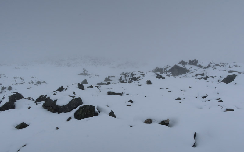
Then we headed up the fell ridge toward the northwest. Now the weather worsened: the cloud thickened and visibility decreased, the headwind strengthened and snow began to fall with the wind. At first we could ascend along snowfields, then again came broken rocky and bouldery terrain; a lot of new snow had already fallen and it partly covered the rocks. Using the GPS map we navigated upward; visibility was minimal and even our glasses were iced over. When the slope then eased and the direction was no longer obvious, we had to use the GPS by selecting a point on the map and following the line the device showed. In the snow‑covered boulder field, especially descending was difficult; one slip and a shin injury occurred.
We eventually reached the ridge leading to Gállanvággi. We took a chocolate bar break sheltered by a large rock, then continued. Lower down visibility improved and soon we could see into the valley. The final stretch was easy walking on a gentle descent. In the valley we searched for a tent site and camped. We had walked 15.72 km, time 8 h 50 min, ascent 867 m, descent 942 m. For dinner we had Reiter Pasta Carbonara with Ham, also a very good meal.
Gállanvággi – Čunovuobmi
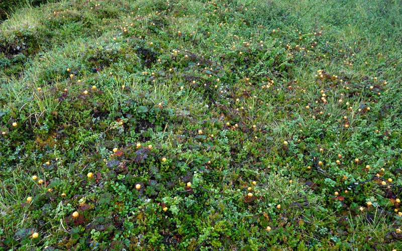
Wednesday 20.8.2025 Wake‑up at 05:00 Norwegian time. It had rained during the night and still rained; clouds were low, the weather slightly warmer. Breakfast was Reiter Rice with Beef and Pepper, followed by coffee and biscuits. We now put on dry socks and plastic bags over our feet; the boots were still wet. After packing our gear we began the journey back to the car. At first we walked while maintaining altitude along the fellside, then descended lower. On the lower slopes there were many cloudberries, which we ate in abundance. We passed a small hut, after which there were even more cloudberries — we ate again.
We then crossed the Čáihnajohka bridge. After that we lost the marked trail and again had to deal with willow thickets. We got through them and returned to the trail; even the crossing of the strongest stream succeeded well at the trail crossing. The Iselva bridge was unchanged; we crossed it and followed the trail back to the car. At the car we changed clothes, packed our gear and drove to Oulu.
Notes: exceptionally bad weather struck this hike, and the fells remained un‑summited. In rainy weather one simply cannot stay dry — rain wets from above and the base layer becomes wet from sweat under the shell clothing. Now it also became clear that Lundhags boots get wet inside. Moisture from foot sweat condenses on the cold inner surface of the boot and wets the socks and insole. The solution would be enough spare socks and insoles. Instead of plastic bags, Gore‑Tex socks could be worth trying. A quilt was used instead of a sleeping bag and, together with a merino base layer and down jacket, it worked well. The lightweight backpack also worked flawlessly. The trekking poles have again lost their tips, so they need replacing.